Maps of the United Kingdom
By Author / Illustrator
Rachel Dixon, Ms. Livi Gosling
Genre
Adventure
Age range(s)
7+
Publisher
Wide Eyed Editions
ISBN
9781786030252
Format
Hardback
Published
04-10-2018
Synopsis
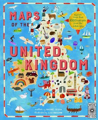
Take a tour of the United Kingdom as you've never seen it before in this fully illustrated set of county maps.
Travel through England, Northern Ireland, Scotland and Wales and meet the incredible people born there, learn about the UK's proud history and discover ancient castles, modern feats of engineering and natural highlights.
Revel in the nation's curiosities, from the spectacular, to the quirky, to the downright strange! Visit Edinburgh Castle with its spectacular views of Scotland's capital; see the home of Roald Dahl in Wales; and why not sample the local delicacies at Wigan's World Pie-Eating Championship?
With colourful maps packed with facts about every inch of this Sceptred Isle, from Land's End to John O'Groats, London to Londonderry, this book makes the perfect companion on long car journeys, summer holidays or rainy Sundays.
As well as acting as your go-to guide to things to see and do, Maps of the UK is also a beautiful atlas of the UK's history and culture, showing how Britons from all over the world have shaped the country for thousands of years.
A fabulous introduction to the UK's geography, history and culture, for readers young and old.
Reviews
Sam
As someone who has moved houses up and down the country many times, this book was a real hit! I'm not a geography buff but I do like to know things about where I am or where I'm going, and this book is just great for that. Maps of the United Kingdom is filled with fascinating facts and figures about every county in the United Kingdom, from the northern most tip of the Western Isles of Scotland and Shetland to the southern most point of Cornwall and the Scilly Isles. While not the ideal book for an in-depth study of a particular place, this book is a real page turner, numerous interesting facts are outlined using easy to understand language, suitable to fuel an inquisitive young mind. For example, Gordon Ramsay's home town of Glasgow boasts the third oldest underground metro line in the world, after London and Budapest, however it has only 15 stops. Much further south in Bristol, where the anonymous graffiti artist Banksy is thought to come from, is the Clifton Suspension bridge, the location of the first modern bungee jump in 1979. The format of this book is based on the principle of any map or atlas, with the outline of a county or counties across a double page spread; specific facts and information about the various towns and cities are then plotted appropriately across the county. Each of these nuggets of knowledge is accompanied by a small coloured illustration, making the overall effect immensely appealing to a young reader. Needless to say, my children turned immediately to the places they knew and had visited but since every county also identifies it's local celebrities, they were very quickly drawn to other places in the UK they had never visited. So while the Roald Dahl museum may be in Great Missenden, Buckinghamshire, the man himself was born in Cardiff. For any primary school teacher trying to encourage their children to read more non-fiction, this book is ideal. Plenty of fun facts to encourage readers to read on without the overwhelming, sometimes off-putting pages and pages of black and white print, common to many non-fiction text. My entire family, young and old, thoroughly enjoyed looking through this book and the discussions that followed were varied and accessible to all. Who needs a travel guide when you've got a copy of Maps of the United Kingdom? 112 pages / Ages 7+ / Reviewed by Sam Phillips, teacher.
Suggested Reading Age 7+
 Mr Dog and the Rabbit Habit (Mr Dog)
 Gargantis
 Blast Off!
 World's Greatest Liar: 2016